
Exploring the Geocreative Blueprint
Have you ever wondered how engineers tackle the massive challenge of upgrading a complex structure like a hydroelectric dam? Traditional photography and human observation simply fall short when dealing with steep mountainous terrain, deep underwater pipes, and tight, labyrinth-like turbine halls.
Enter the Geocreative Blueprint, a sophisticated, multi-tiered pipeline designed to translate raw physical elements into an exact, actionable digital twin. Because a single sensor isn't enough, this system captures data across multiple environmental layers simultaneously:
The Macro Exterior: Aerial drones scan the surrounding terrain to generate massive 3D orthomosaics, which are highly detailed and geometrically corrected topographical maps.
The Hazardous Deep: To inspect submerged intake structures without risking human divers or disturbing aquatic life, biomimetic robotic fish swim through the deep waters to safely capture essential data.
The Macro Interior: Inside the facility, operators use SLAM (Simultaneous Localization and Mapping) technology to generate a complete digital twin of the turbine hall simply by walking through it, entirely bypassing the need for static tripod scanners.
Once collected, artificial intelligence pipelines like flyix use computer vision to automatically scan millions of data points for structural anomalies.
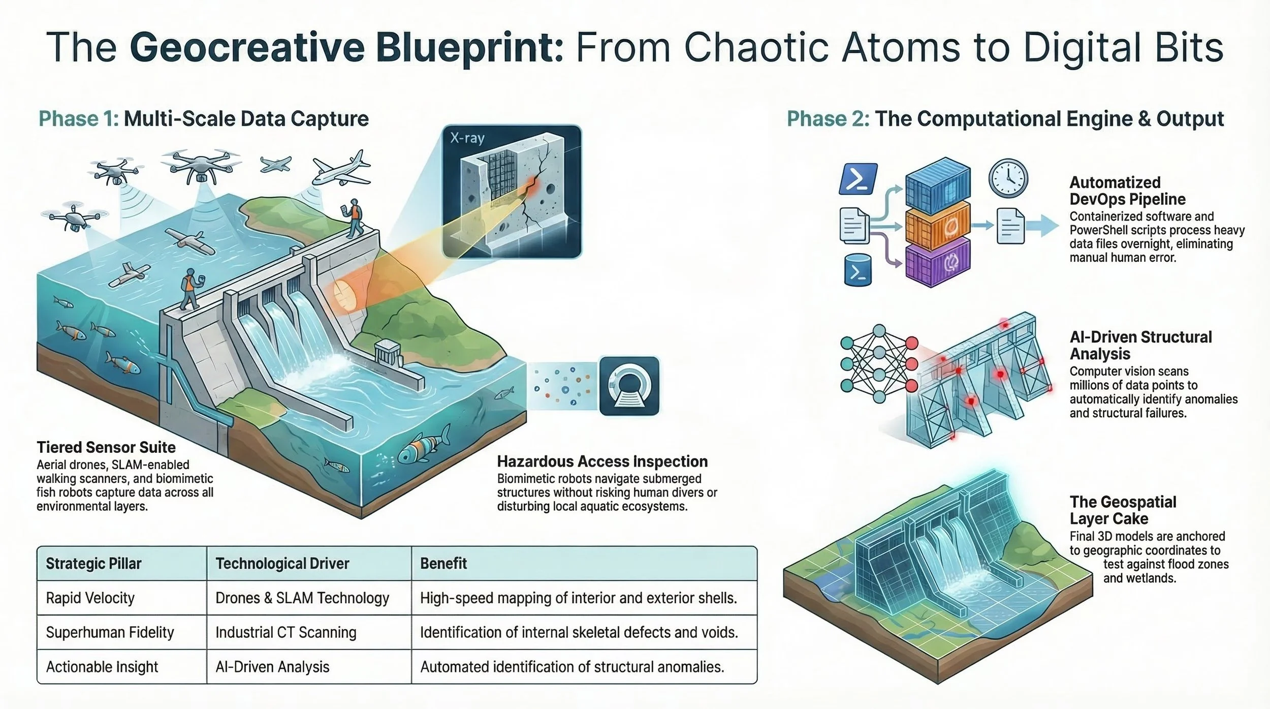
However, mapping the exterior shell isn't enough to understand the health of moving machinery like turbine blades. To solve this, engineers use industrial CT scanning, utilizing X-rays to generate a volumetric view of a component's internal skeleton. This allows teams to locate microscopic void spaces and internal stress fractures long before a catastrophic failure occurs.
Gathering this multi-scale data generates massive, cumbersome point cloud files. To prevent logistical bottlenecks, the blueprint relies on a robust DevOps infrastructure. By wrapping complex software into isolated Docker containers and using automated PowerShell scripts, the system processes these heavy files overnight. It transforms disorganized raw data into lightweight, optimized polygon meshes that can be integrated directly into standard CAD software.
Finally, these isolated 3D models are anchored to exact geographic coordinates, allowing engineers to test how the structure holds up against shifting wetlands or specific flood zones.
By combining the rapid velocity of drones and SLAM, the superhuman fidelity of industrial CT scans, the standardized reliability of automated pipelines, and the actionable insight of AI analysis, the Geocreative Blueprint eliminates physical guesswork. It strips away visual noise and provides engineering teams with a single, highly structured mathematical coordinate system they can completely trust